
Summary
Rapid urban population growth is placing pressure on land, infrastructure, and housing across U.S. metro regions. Effective land development strategies combine smart zoning, infrastructure planning, mixed-use development, transit-oriented growth, and environmental stewardship. When cities coordinate policy, private investment, and community needs, they can expand housing supply, improve livability, and support sustainable economic growth while avoiding sprawl and infrastructure overload.
Understanding the Pressure on Urban Land
Urban regions across the United States are expanding at a historic pace. According to the U.S. Census Bureau, more than 83% of Americans now live in metropolitan areas, and population growth is increasingly concentrated in fast-growing cities such as Austin, Phoenix, Raleigh, and Tampa.
This growth creates a complex challenge for planners, developers, and local governments. Cities must accommodate new housing, commercial development, and transportation systems without overwhelming existing infrastructure or sacrificing environmental quality.
Land development strategies are the frameworks used to guide how land is used, built, and connected. When implemented effectively, they allow cities to:
- Expand housing supply
- Improve transportation efficiency
- Support economic growth
- Protect natural resources
- Maintain livable neighborhoods
Poorly planned development, by contrast, can lead to traffic congestion, housing shortages, environmental damage, and costly infrastructure expansions.
The most successful urban regions approach land development as a coordinated system rather than isolated projects.
Smart Zoning and Flexible Land Use Policies
Zoning regulations shape nearly every aspect of urban development. Traditional zoning often separates residential, commercial, and industrial uses into distinct districts, which historically encouraged suburban sprawl.
Modern land development strategies increasingly rely on flexible zoning frameworks that allow mixed uses and higher density in appropriate locations.
Cities across the U.S. are experimenting with reforms such as:
- Mixed-use zoning, allowing housing, retail, and offices in the same district
- Upzoning near transit corridors to support higher density
- Accessory dwelling units (ADUs) to increase housing supply in existing neighborhoods
- Form-based codes that regulate building design rather than land use categories
For example, Minneapolis eliminated single-family zoning in 2019, allowing duplexes and triplexes in residential neighborhoods. The goal was to increase housing supply and reduce affordability pressures.
While zoning reform alone does not solve housing shortages, it removes major regulatory barriers that limit development.
Infrastructure-First Development Planning
One of the most common mistakes in rapidly growing urban areas is allowing development to outpace infrastructure capacity.
Successful land development strategies prioritize infrastructure planning before large-scale construction begins.
Key infrastructure elements include:
- Transportation networks
- Water and wastewater systems
- Power and broadband access
- Stormwater management
- Public schools and community facilities
Cities such as Frisco, Texas have used infrastructure-first planning to support rapid growth. Over the past two decades, the city coordinated road expansions, utilities, and school construction before approving major residential subdivisions.
This approach reduces costly retrofits later and ensures new neighborhoods function efficiently from the beginning.
Developers also benefit because predictable infrastructure investments reduce project risk.
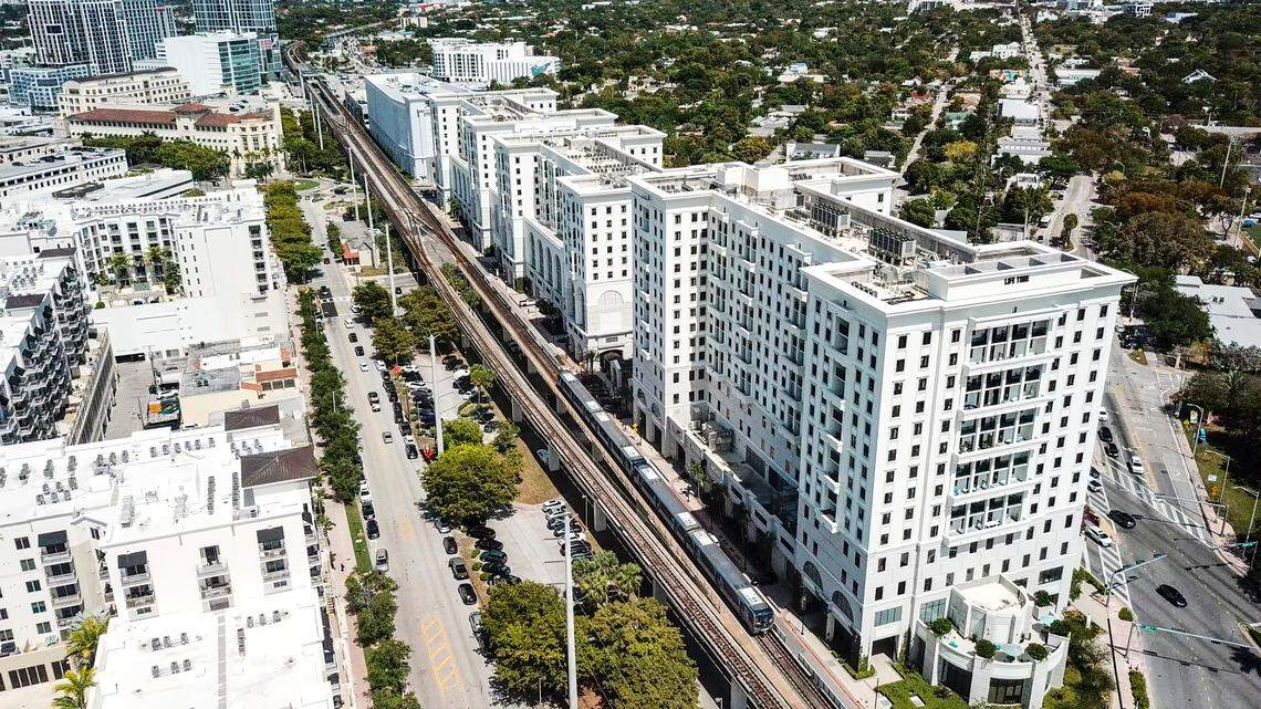
Transit-Oriented Development (TOD)
Transportation and land use are deeply interconnected. When development spreads far from employment centers, residents rely heavily on cars, increasing congestion and infrastructure costs.
Transit-oriented development (TOD) addresses this problem by concentrating higher-density housing, retail, and offices near public transit stations.
TOD projects typically feature:
- Walkable neighborhoods
- Mixed-use buildings
- Reduced parking requirements
- Direct access to rail or bus lines
- Pedestrian-friendly street design
Cities such as Denver and Arlington County, Virginia have successfully implemented TOD along transit corridors. Arlington’s Rosslyn-Ballston corridor, for example, concentrated development around five metro stations while preserving nearby single-family neighborhoods.
The result was a 40-year transformation that produced millions of square feet of office space and thousands of housing units, all within walkable urban centers.
TOD reduces traffic congestion, lowers transportation costs for residents, and supports local businesses.
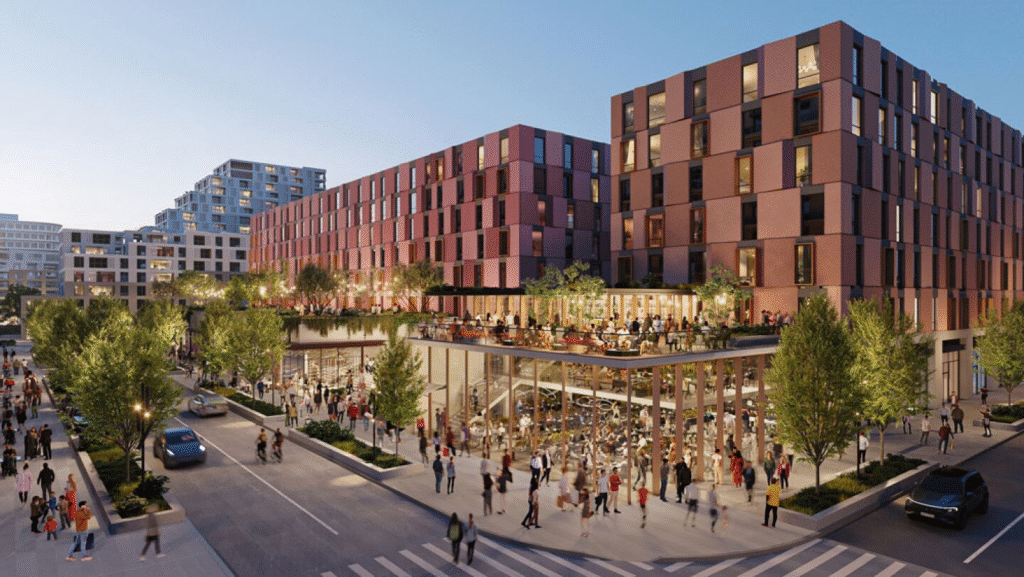
Strategic Density Without Overcrowding
Higher density is often essential in growing cities, but density must be planned carefully to maintain livability.
Strategic density focuses on placing growth in targeted areas where infrastructure and services already exist.
Common strategies include:
- Mid-rise residential buildings along transit corridors
- Urban infill projects on underused land
- Redevelopment of aging commercial properties
- Conversion of office buildings into housing
- Vertical mixed-use developments
For example, several U.S. cities have begun converting underutilized office buildings into residential apartments following pandemic-era shifts toward remote work.
In Washington, D.C., programs encourage office-to-residential conversions in the downtown core to increase housing supply while revitalizing business districts.
Density works best when paired with public amenities such as parks, schools, and transportation access.
Redevelopment and Urban Infill Opportunities
Expanding outward is not always the most efficient development strategy. Many cities contain significant underutilized or vacant land within existing urban boundaries.
Urban infill development focuses on redeveloping these sites instead of expanding into undeveloped areas.
Typical infill opportunities include:
- Vacant lots
- Surface parking lots
- Aging shopping centers
- Former industrial sites
- Underused office complexes
A well-known example is the redevelopment of Denver’s former Stapleton Airport into a large mixed-use community known today as Central Park Denver. The project transformed a massive underused site into housing, parks, schools, and commercial districts.
Infill development offers several advantages:
- Existing infrastructure reduces development costs
- Shorter commute distances
- Revitalization of older neighborhoods
- Reduced pressure on rural land
However, infill projects often require careful community engagement to address concerns about traffic, parking, and neighborhood character.
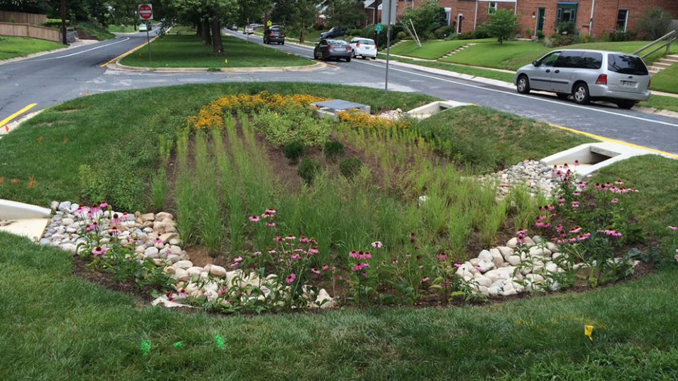
Environmental and Resilience Considerations
Modern land development must also address environmental risks and climate resilience.
Urban regions increasingly face challenges such as flooding, heat islands, and water scarcity. Smart land development integrates environmental considerations from the earliest planning stages.
Key strategies include:
- Preserving wetlands and natural floodplains
- Incorporating green infrastructure for stormwater management
- Expanding urban tree canopies
- Designing energy-efficient buildings
- Protecting wildlife corridors and open space
Cities such as Portland, Oregon, and Seattle have integrated green infrastructure into development planning, using bioswales, permeable pavements, and urban forests to manage stormwater naturally.
These measures reduce long-term infrastructure costs while improving environmental quality and public health.
Public-Private Partnerships in Land Development
Large-scale urban development rarely succeeds through government or private investment alone. Public-private partnerships (PPPs) are increasingly used to coordinate financing, land assembly, and infrastructure construction.
In PPP arrangements, cities may contribute land, zoning approvals, or infrastructure investments while private developers finance and build projects.
Successful examples include:
- Hudson Yards in New York City
- The Wharf redevelopment in Washington, D.C.
- Atlanta BeltLine mixed-use development
These projects combine housing, retail, offices, public space, and transit improvements within coordinated development districts.
While PPPs can accelerate growth, transparency and community involvement remain critical to maintaining public trust.
Data-Driven Planning and Technology
Advanced data tools are transforming how cities plan land development.
Geographic information systems (GIS), satellite imagery, and predictive modeling allow planners to analyze population trends, transportation patterns, and infrastructure capacity with far greater accuracy.
Cities are increasingly using data to:
- Forecast housing demand
- Identify optimal development sites
- Evaluate infrastructure capacity
- Monitor environmental impacts
- Simulate zoning changes
For instance, Austin’s land development code reform process relied heavily on GIS modeling to test how zoning adjustments would affect housing supply and neighborhood density.
Data-driven planning helps cities make more informed decisions while reducing political conflicts around growth.
Community Engagement in Development Planning
Even technically sound land development strategies can fail without community support.
Residents often worry about:
- Traffic congestion
- School overcrowding
- Loss of neighborhood character
- Rising housing costs
Effective planners address these concerns through early and consistent community engagement.
Successful engagement strategies include:
- Public workshops and charrettes
- Digital planning platforms
- Transparent development proposals
- Clear communication of long-term benefits
Cities that actively involve residents tend to experience fewer project delays and legal challenges.
Community input often leads to better designs that integrate parks, walkable streets, and neighborhood services.

Frequently Asked Questions
What is land development planning?
Land development planning refers to the process of organizing how land is used for housing, commercial activity, infrastructure, and public spaces. It involves zoning policies, infrastructure design, environmental considerations, and economic planning to guide sustainable urban growth.
Why is land development important in growing cities?
As populations increase, cities must accommodate housing, jobs, and transportation. Effective land development ensures growth occurs efficiently while maintaining livable communities and preventing infrastructure overload.
What is transit-oriented development?
Transit-oriented development focuses housing and commercial activity near public transit stations to reduce car dependency, encourage walking, and improve access to jobs and services.
How does zoning affect land development?
Zoning laws determine what types of buildings can be constructed in specific areas. Flexible zoning policies can encourage mixed-use development and increase housing supply.
What is urban infill development?
Urban infill involves building on vacant or underused land within existing city boundaries rather than expanding into undeveloped suburban areas.
How do cities manage environmental risks during development?
Cities incorporate green infrastructure, floodplain protections, tree planting, and sustainable building standards to reduce environmental impacts and improve resilience.
What role do developers play in land development strategies?
Private developers finance and construct many projects, but they operate within planning frameworks set by local governments, including zoning rules and infrastructure requirements.
What are public-private partnerships in development?
Public-private partnerships involve collaboration between government and private developers to finance and implement large urban development projects.
How can land development help address housing shortages?
Strategies such as zoning reform, increased density near transit, and redevelopment of underused land can significantly expand housing supply.
What is the biggest challenge facing urban land development today?
Balancing population growth, housing affordability, infrastructure capacity, and environmental protection remains one of the most complex challenges for modern cities.
Building Cities That Can Grow Without Breaking
Urban regions will continue to attract people seeking jobs, education, and opportunity. The challenge is not whether cities will grow, but how that growth will be managed.
Thoughtful land development strategies allow cities to expand housing, support economic activity, and protect environmental resources at the same time. Success requires collaboration among planners, developers, policymakers, and communities.
When cities plan growth carefully, they can transform rising population pressure into stronger, more resilient urban environments.
Key Insights for Urban Growth Planning
- Urban population growth requires coordinated land development strategies
- Flexible zoning policies support housing supply and mixed-use communities
- Infrastructure planning should precede major development approvals
- Transit-oriented development reduces congestion and improves mobility
- Urban infill projects maximize existing land and infrastructure
- Environmental planning strengthens long-term resilience
- Public-private partnerships enable large development projects
- Data-driven planning tools improve decision-making